Artificial Intelligence has found application in many areas, where its particular ability to find patterns in data makes it a useful tool. Let’s look at AI’s application to Emergency Management, a critical activity in today’s world of climate change, pandemics, and social unrest.
Emergency Management seeks to minimize the impact, on people and property, of emergencies such as earthquakes, hurricanes, floods, disease, and terrorism. EM involves four kinds of interrelated and sometimes overlapping activities:
- Mitigation (also called Disaster Risk Reduction) – steps taken to reduce the likelihood (e.g., forest management to reduce wildfire risk) or reduce impact (flood protection levies) of emergencies
- Preparation – equipping responders and the public with tools and knowledge that will minimize emergency impacts. Examples include stockpiling personal protective equipment for pandemics, and training Community Emergency Response Teams
- Response – actions taken during an emergency or in its aftermath, to prevent further suffering or financial loss. International relief efforts after a devastating earthquake are an example of this, as is medical care for the victims of a pandemic
- Recovery – work to return communities back to ‘normal’ after an emergency, for example rebuilding destroyed structures or re-opening a shut down economy.
Deep neural networks, currently a leading edge of AI, map patterns in data to useful interpretations of the data, such as the condition of a building, the likelihood of a flood, or the best evacuation route. This kind of information can be very useful for the planning, prediction, situation assessment, and decision making that are at the heart of Emergency Management.
Here are some examples of AI’s use in the four kinds of EM activity:
Mitigation
Mitigation seeks to reduce the risks associated with emergencies and disasters. Two ways this can be done are by recognizing human-made dangers and reducing them, or by predicting dangerous natural phenomena in time for actions to be taken to reduce their impact.
Poor urban areas are especially vulnerable to disasters and poverty data is in scare supply and difficult to collect. Researchers at Oak Ridge National Laboratory in the US have developed a AI-based technique to identify poor, informal settlements from high-resolution satellite imagery. Their approach uses a variety of spatial, structural, and contextual features to classify areas as formal, informal, and non-settlement classes. The method was tested in Caracas, Kabul, Kandahar, and La Paz, and demonstrated that good accuracy could be obtained using the same features in these diverse areas.
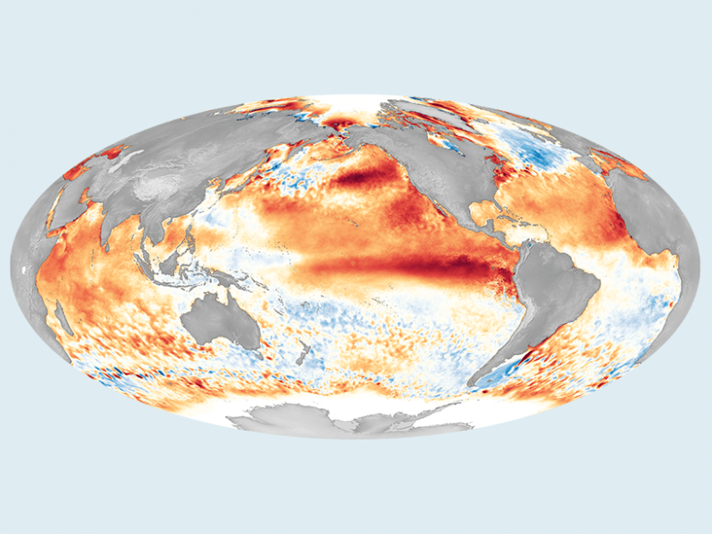
El Niño is a climate phenomenon that disrupts normal weather, leading to intense storms in some areas and droughts in others. It happens at irregular intervals of two to seven years, and lasts nine months to two years. The farther in advance an El Niño event can be predicted, the better a region can prepare for it. Recently deep neural networks have been able to forecast El Niño 18 months in advance, which is an improvement of 6 months over previously used methods.
In California, two high school students invented a device to predict the probability of a forest fire occurring. The device is placed in the forest and takes real-time photographs together with measurements of humidity, temperature, carbon monoxide/dioxide, and wind. This data is then used with a deep neural network to predict the probability of a fire.
Preparation
A primary responsibility of emergency managers is to develop good plans to execute when disaster strikes. Such plans must deal with patterns of natural and social phenomena, and AI can help analyze these patterns and guide effective planning.
For example, Google has been partnering with India’s Central Water Commission to develop AI-enabled flood forecasting and early warning. Google uses a variety of elements such as historical events, river level readings, terrain and elevation, to run hundreds of thousands of simulations for each location to create river flood forecasting models that can more accurately predict where and when a flood might occur, and also how severe it will be.
Response
Emergency response must provide aid where it is needed. Knowing where and what sort of aid is needed is a challenge, especially in large-scale disasters. Our modern world is flooded with situational information from social media, surveillance cameras (fixed, drones, satellites), and internet-of-things sensors. However, it is very challenging for emergency managers to sort through and interpret this data. This is an ideal application for AI.
A system called Artificial Intelligence for Disaster Response (AIDR) has been developed to help analyze Twitter tweets during emergencies and disasters. The system is available as free and open software, and it is designed to be tailored to responder needs. The responder first identifies keywords and/or hashtags that are used as a preliminary filter for tweets. Next responders identify topics of interest such as “Medical Needs” or “Sheltering”, and manually tag example tweets in each category. A deep neural network then learns to classify relevant tweets in each category, and automatically streams relevant information to responders.
AI is being used in the fight against the ongoing COVID-19 pandemic. Deep neural networks are being used to identify patterns in medical imagery in lungs and heart that will allow early detection and personalized therapies. AI is also being used to identify research and drugs most likely to lead to COVID-19 treatments and vaccines, and to track the disease by monitoring the deluge of data on social media and the internet.
Recovery
During disaster recovery a wide range of activities are undertaken to attend to casualties and survivors, restore buildings and infrastructure, and re-establish social systems and businesses. When international aid is involved, complex interactions among multiple organizations must be coordinated. Situation assessment, resource allocation, and planning can all be supported by AI’s ability to recognize patterns in data.
For example Google, in collaboration with the United Nations World Food Program Innovation Accelerator, has developed a system for automatic damage assessment using very high-resolution satellite imagery. The system uses a deep neural network to identify buildings and compare their condition before and after the disaster. This automated damage assessment can greatly improve the timeliness and effectiveness of recovery efforts for disasters that damage large numbers of structures, such as the 2010 Haiti earthquake, which required assessment of over 90,000 buildings in the Port-au-Prince area alone.
AI and EM
AI’s pattern recognition capability can be an invaluable asset for planning, prediction, situation assessment, and decision making. These activities are critical to many lines of work, especially Emergency Management.
